Sunday 2 October 2011

Warangal district


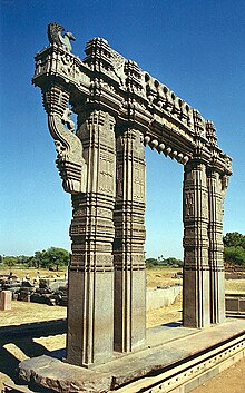
Warangal District (Telugu: వరంగల్ జిల్లా, Urdu: وارنگل ضلع) is located in the northern area in the state of Andhra Pradesh, India. The administrative seat is Warangal.

Warangal District has an area of 12,846 km², and a population of 3,246,004 of which 19.20% was urban as of 2001. The district is bounded by Karimnagar District to the north,Khammam District to the east and southeast, Nalgonda District to the southwest, andMedak District to the west. Warangal is well known for its granite quarries (notably the black and brown varieties) and as a market for rice, chilies, cotton, and tobacco.

Culture

The district hosts the Samakka-Saramma Jatara (congregation). Every two years, approximately ten million people converge over three days around the small village of Tadvai, 90 km from Warangal city. This fair commemorates the valiant fight put up by a mother-daughter combination with the reigning rulers over an unjust law.
Warangal is an excellent abode of fine arts and literature. Many art forms from folklore to the modern arts of singing, dance, painting, poetry and films have been flourished in the land.

Demographics

According to the 2011 census Warangal district has a population of 3,522,644 , roughly equal to the nation of Lithuania or the US state ofConnecticut.[6] This gives it a ranking of 82nd in India (out of a total of 640). The district has a population density of 274 inhabitants per square kilometre (710 /sq mi) . Its population growth rate over the decade 2001-2011 was 8.52 %. Warangal has a sex ratio of 994females for every male, and a literacy rate of 66.16 %.

Transport

Road transport


National Highway 202 (India) between Hyderabad - Bhopalpatnam (Chhattisgarh) connecting the district through Jangaon, Kazipet, Hanamkonda, Mulug, Eturnagaram. Warangal city is surrounded with towns like Bhoopalpally , Parkal, Mahabubabad, Narsampet, Torrur and Jangaon each 30-90 kilometers.


Warangal is about 140 km by road from Hyderabad (capital of Andhra Pradesh). Rail transport


The city has to Railway stations called {Warangal and Kazipet) which connects south and north India and the Kazipet is major railway junction. Airport


Hyderabad International Airport is about 3 ½ hours by road from Warangal city. This district has a small airport in Mamnoor, which can accommodate small aircraft like the ATR 42. This airport is currently used by police.

Divisions

Warangal Fort

Mandals include:
1. Cheriyal
2. Maddur
3. Narmetta
4. Bachannapet
5. Jangaon
6. Lingala Ghanpur
7. Raghunathapalli
8. Ghanpur (Station)
9. Dharmasagar
10. Hasanparthy
11. Hanamkonda
12. Wardhannapet
13. Zaffergadh
14. Palakurthi
15. Devaruppula
16. Kodakandla
17. Raiparthy
18. Thorrur
19. Nellikudur
20.Narsimhulapet
21. Maripeda
22. Dornakal
23. Kuravi
24.Mahabubabad
25. Kesamudram
26. Nekkonda
27. Gudur
28. Kothaguda
29. Khanapur
30. Narsampet
31.Chennaraopet
32. Parvathagiri
33. Sangam
34. Nallabelly
35. Duggondi
36. Geesugonda
37. Atmakur
38. Shayampet
39. Parkal
40. Regonda
41. Mogullapalle
42. Chityal
43. Bhupalpalle
44. Ghanapur
45. Mulug
46. Venkatapur
47. Govindaraopet
48. Tadvai
49. Eturnagaram
50. Mangapet
50. Chityal (Warangal Dist) 
51. Warangal